Inputs:
- A ESRI TIN or PolygonZ TIN
Outputs:
- A polygon feature class
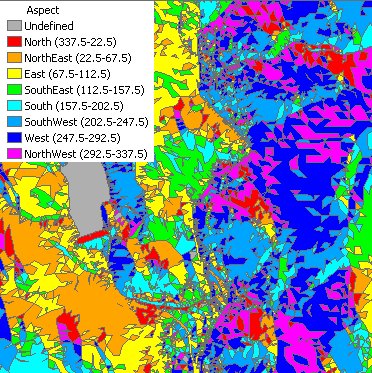
- A new field ET_ACode will be added to the
polygon attribute table. The values in this field will indicate the aspect
groups.
- N - North ( 0 to 22.5 and 337.5 to 360)
- NE - North East (22,5 to 67.5)
- E - East (67.5 to 112.5)
- SE - South East (112.5 to 157.5)
- S - South (67.5 to 112.5)
- SW - South West (202.5 to 247.5)
- W - West (247.5 to 292.5)
- NW - North West (292.5 to 337.5)
- U - Undefined - Slope = 0
Command line syntax - two different toolbox tools available depending on the type of the input TIN. Check the color coding for specifics.
| ETS_GPAspectFromEsriTIN <Input TIN> <Out Feature Class> |
| ETS_GPAspectFromPolygonZTIN <Input TIN> <Out Feature Class> |
Parameters
| Expression | Explanation |
|---|---|
| <Input TIN> | An ESRI TIN layer or dataset |
| <Input TIN> | A PolygonZ TIN (feature class) |
| <Out Feature Class> | A String - the full name of the output feature class. |
Scripting syntax
ETS_GPAspectFromEsriTIN (Input TIN, Out Feature Class)
ETS_GPAspectFromPolygonZTIN (Input TIN, Out Feature Class)
See the explanations above:
<> - required parameter
{} - optional parameter
All ESRI
products mentioned are trademarks of Environmental Systems Research
Institute, Inc.
Copyright: Ianko Tchoukanski